Warning: fopen(/var/www/web438/html/multi-touch/engine/cache/system/cron.php): failed to open stream: Operation not permitted in /var/www/web438/html/multi-touch/engine/modules/functions.php on line 280 Warning: fwrite() expects parameter 1 to be resource, boolean given in /var/www/web438/html/multi-touch/engine/modules/functions.php on line 281 Warning: fclose() expects parameter 1 to be resource, boolean given in /var/www/web438/html/multi-touch/engine/modules/functions.php on line 282 multitouch sphere » Multitouch software Solution Globe Earth interactive virtual Globus Erde мультитач виртуальный Глобус Земля
Multitouch Solution
  english german russia  
 
 
Tag Cloud » multitouch sphere 

Automatic marine route navigation calculation service (NRCS)

Purpose of the software


The route calculation service is intended for calculation of a sea route from A to B preventing crossing land areas and shoals. The software receives from external application geographical coordinates of start and end points of the route and returns set of coordinates (Latitude and longitude) of the calculated route.


As an additional task the service can receive navigational data provided by Raytheon bridge navigational system NCS ECDIS as NMEA sentences and send out the data via web protocol.


This software help you to find the quickest or safest route on your next trip. It is automatic routing software with GPS features as well as a useful set of Marine navigation features.
Regarding "course optimization" and "routing" Mr.Pryszo write:
“Course optimization optimizes the course of the vessel along the great circle 
route. Alternately, for short legs, optimization can be calculated using the 
vessel's  rhumb line: The resulting course will most probably be significantly 
different than the great circle route."
Via internet connection is it easy to track your boats position on the Google or Bing Maps. It is ideal for friends and family to keep in touch.
It is ideal for trip planning with functions like:
·         Automatic Route Generation,
·         Display and edit routes,
·         Interface to GPS units,
·         Compute optimal routes,
·         useful set of Marine navigation features,
·         course optimization or routing.

This software help to find the quickest or safest route on your next trip. It is automatic routing software with GPS features as well as a useful set of Marine navigation features.

Regarding "course optimization" and "routing" Mr.Pryszo write:

"Course optimization optimizes the course of the vessel along the great circle route. Alternately, for short legs, optimization can be calculated using the vessel's  rhumb line: The resulting course will most probably be significantly different than the great circle route".

Via internet connection is it easy to track your boats position on the Google or Bing Maps. It is ideal for friends and family to keep in touch.


It is ideal for trip planning with functions like:

·         Automatic Route Generation,

·         Display and edit routes,

·         Interface to GPS units,

·         Compute optimal routes,

·         useful set of Marine navigation features,

·         course optimization or routing.


Basic Principles of the software


The route calculation service is installed on Windows computer running under Win32 or Win64 and works as a web service that receives and sends data from and to main application via http protocol.

The route calculation service does not have user interface and all the calculations are made and operated from the main application.

The route calculation service consists of the following software modules


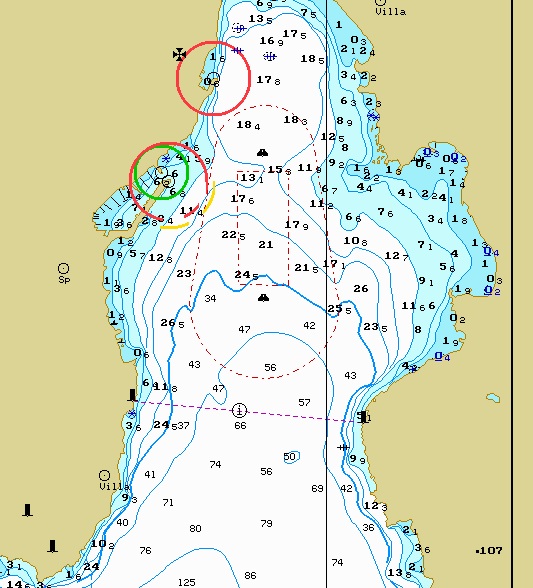
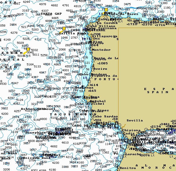
Static 3D bathymetric data model built from vector navigational charts. The bathymetric data model takes into account spot soundings; depth contours (isobaths); land areas, intertidal areas and shoals. The initial data used by the bathymetric model were digitized from marine paper nautical charts issued by national hydrographic offices. The only marine charts suitable for coastal or deep sea navigation are used in the bathymetric model. Marine chart scale can vary from 1:5000 for harbor and berthing charts to 1:5,000,000 for open sea areas.


The following pictures provide examples of bathymetric data depicted on the large scale harbor chart and small scale open sea chart.


Marine chart Marine chart


•   Software algorithm for defining No Go area based on the bathymetric model. The algorithms takes into account predefined safety depth based on a vessel draft and calculates areas not suitable for navigation – land areas and shoals with a depth less than the predefined safety depth.


•   Software algorithm for creation of safe navigational route from A to B passing around calculated No Go areas. The algorithm firstly adds additional waypoints to pass around the No Go areas and then optimizes the resulted route in a way to make it shorter and remove unnecessary waypoints provided all of the route legs are lying within safe water.


•   Web service that receives data from external applications – route start and end points and navigational data from bridge system, sends the data for procession by the aforementioned software algorithms and provides results of calculations back to the external application. The service also calculates and returns distance to the final point and arrival time taking into account vessel speed provided by the external application.


Different types of calls and calculations performed by software


To minimize time required for different types of calculations, the route creation software process different types of calls separately. The following operations will be performed depending on request (call) received from the main application.


Defining limits of No Go areas based on vessels safety depth


Since the vessel safety depth is not changed dynamically, this operation could be performed once during initial configuration of the system. The input parameter received from main application is safety depth that is defined as vessel draft plus safe under keel clearance. The software receive the safety depth and define NO Go areas for a sailing area (this could be the water area worldwide). Result of the calculation is stored in the server for future use by route calculation algorithms.


Rough route calculation.


Based on the start and end point received from the main application, this software returns a number of waypoints providing safe but not the shortest route from A to B. Resulted route can contain unnecessary waypoints and route legs lying within safe water that were added to pass around unsafe No Go areas. The rough route can provide a user quick access to results of the calculation – estimated distance and time to the end waypoint.


Create new customer rout with drag & draw. State: after calculation.


Precise route calculation.


Upon creation of the rough route, this software can perform the route smoothing calculation.  It removes unnecessary waypoints provided that the resulted route lies within safe water.

The precise route calculation can be performed right after the rough calculation so user can get quick route immediately and precise route after some time required by this software for calculations.


Transmitting of the bridge system navigational data


The navigational data received from vessels bridge system as NMEA sentences are sent via web service in real time.

The following navigational data are received from Raytheon bridge navigational system NCS ECDIS and transferred via web service: GPS position, Echo sounder (depth), LOG (speed), Wind meter, Gyro (heading).

Actual vessel route currently used by bridge system can also be transferred via web service if the route is provided by the Raytheon for output as standard NMEA sentences.


Route calculation service limitations


1. The route calculation service does not take into account administrative routing options such as territorial sea limits, prohibited and restricted areas, recommended routes and traffic separation schemes.


2. The bathymetric data model and route calculation service does not consider changes in water level caused by tides and environmental factors such as wind, significant waves and currents. Ocean and sea depth is defined from various water levels which are used on paper charts for soundings and depth contours.


3. The route calculation service does not take into account length, width and height of vessel. The vessel is considered as a material point with safety depth.


4. Calculated waypoint positions are referenced to WGS-84 horizontal chart datum if correction to WGS-84 is known from paper and electronic charts.


5. Since land and shoal positions on sea navigational charts used for route calculation can differ from chart display provided by main program (Google or Virtual Earth), it is possible that resulted route crosses land or shoal when displayed in the main program.


6. The route calculation service can work improperly in inland and harbor areas because it does not consider narrow channels and rivers and small port facilities like berths and wharfs.


7. The route calculation service does not work in northern latitudes higher than 80 degrees due to absence of proper bathymetric information in this area.


Hardware and software operating platform requirements


The route calculation service is installed on dedicated server with the following minimal requirements

Processor – Intel PentiumCore2 DUO Quad;

RAM – 4 Gb;

HDD – 160 Gb;

CD/DVD-ROM drive – standard;

Keyboard, mouse – standard;

OS SW – Windows Server 2003 (English version);


The server running route calculation service should be connected via TCP/IP LAN to a station with the main program and to bridge navigational system.


Multitouch Earth application features: Marine routing

Actual Route, Historical Route, Captain’s Route


Actual route is the real route the ship traveled from its start location. The length of the actual route is configurable, e.g. it may show the travel in the last seven days or the last 100 miles. The route information is obtained from the ship navigation system and is based on the actual GPS data.

Historical route is the whole real route of the yacht since its first started recording (generally, the first time it left the shipyard). It is also built based on the actual GPS data from the ship’s navigation system.

Captain’s route is the most recent planned route of the ship’s captain. It generally starts at the ship’s current position and goes to its currently planned final destination. The final destination is usually marked with a predefined icon.

It is possible for the captain’s route to start at some future planned destination. Multitouch Earth simply displays the information received from the ship’s navigation system – no checks are performed.


Start of the Multitouch Earth application


When Multitouch Earth client application starts, it shows the ship in the center of the screen on the map of the Earth at its current position. The ship is shown as a predefined icon. The Earth is oriented as follows: North – up, South – down; West – left; East – right. The Icon of the ship is shown roughly pointing in the actual direction of travel.

By default after the start the Multitouch Earth application shows follows two routes:


 •   Actual route
 •   Captain’s route


Starting screen with the actual and the captain route


The default settings can be changed if needed by the system administrator, so that it is possible to show the first view without the captain’s route or show the active route for the last 7 days (independent of the length of the current trip).

By touching the icon of the yacht at the actual position user gets a menu which allows him to perform the following operations:

 •   Turn ship’s actual route on/off

 •   Turn a label with actual longitude, latitude and speed on/off

 •   Turn a label with actual weather information as temperature, wind, air pressure on/off

 •   Turn a label with weather forecast for this region on/off.

 •   Zoom in and zoom out (this is needed for not multi-touching monitors – on multi-touch monitors this function is available via a gesture)


 Types of customer route


User can also make his or her own route or modify an existing planned route (captain’s route), thus creating a User’s Route (UR).

After a user’s route is defined, Multitouch Earth calculates it and displays along with the other displayed routes. The calculation is done by the server and finds the shortest path through the waterways between the points specified by the user. Here are a few ways a user’s route can be created:


1. Building of a user’s route from the actual position of the ship – current position of the ship is the first point of the new route

   a. Touch a new destination at the map

   b. Define it as a new destination via a context menu


2. Building of a User Route from any start position to any destination position (these two points become the start and end points of the new route) 

   a. Touch a location on the map and define it as a start point of a route

   b. Touch a location on the map and define it as an end point of a route


3. Drawing of a user route by defining multiple points along the new route

   a. Touch a location on the map and define it as a start point of a route

   b. Continue moving along the planned route using either a mouse or a finger on a multi-touch screen


4. Changing of the captain route

   a. Push the button “Edit Captain Route”


5. Drawing of a user’s route from the actual position of the yacht.

    a. Touch the ship icon and draw the new route line with a finger


6. Changing of the captain route

  a. touches point on the sea an then choice context menu “continue to here” or

  b. delete waypoint(s)

  c. moves waypoint to its new position


User can delete or save his UR with some commentaries and attribute settings (e.g. kind of line, color of line).


 Building of a User Route from the actual position of the ship


Building of a user’s route from the actual position of the ship is done with the following steps:

•   Touch a location on the map
•   Define it as the new destination via a context menu
•   Watch the new route between the current location and the new destination appear; this new route is computed to make the sea voyage feasible (that is, avoiding landmasses)

•   User can define the speed and departure time and kick off the recalculation of the route.


Create new customer rout with start and end points. State: before calculation


If user plans a trip from Portugal to California, the original line looks as follows:
After the route is computed, it will be shown as follows:


Create new customer rout with start and end points. State: after calculation


Drawing of an own route

User can draw his own route independent of the actual route and of the captain route. User can also arbitrarily draw the line from one point on the globe to another.


Create new customer rout with drag & draw. State: before calculation.


The line as shown by application Multitouch Earth.


Create new customer rout with drag & draw. State: after calculation.


Then user can define the speed and departure time. To do this user points to any point at the map and marks it as a starting point of a new route. Then he draws a line of a new route. After that he has to choose the speed type and departure date and time and kick off the calculation of the route. Multitouch Earth application shows then digitalized route and shows automatically calculated parameters of this route as its length, duration, time of departure and time of arrival.

This drawn route can be changed in the same way as the captain route. It is possible also to delete this route.


Changing of the captain route


The captain route is given from the captain bridge and will be only shown in the Multitouch Earth.
By default the last planed captain route will be shown.

User can switch ship’s route planned on Captain Bridge on/off. In order to do that the user touches the route line and clicks the menu point for “switch off CR” (CR=captain Route). If user wants to switch the captain route on, then he or she clicks or touches the corresponding menu point in the menu window at the actual ship’s position.


Create new customer rout with “Edit Captain Route”.
State:   Show captain route and ship menu. Before push the button “Edit Captain Route”.


Create new customer rout with “Edit Captain Route”.
State:   After push the button “Edit Captain Route”. The new customer route is created.


Changing of the customer route with continue custom route.
State: Before calculation.


The changes done by the user are for illustrating of user’s ideas. The original captain route stays shown also.


Changing of the custom route


In order to continue any route to a selected point, the user touches point on the sea (with a finger at Globus or with a mouse pointer at a normal PC) and in context menu choice “continue to here”.


Changing of the customer route with continue custom route.
State: After calculation.


In order to change a position of a single waypoint the user touches the waypoint (with a fin-ger at Globus or with a mouse pointer at a normal PC) and moves it to its new position. Lines be-tween other two neighbored waypoints are redrawn by the application


Changing of the customer route with continue custom route.
State: Before moves
Changing of the customer route with continue custom route.
State: After moves


In order to change a line between two  chosen way points the user touches two waypoints (with 2 fingers at Globus or with the help of menu at right button of mouse pointer at a normal PC) and draws a new line from one of these points to another. The operation is finished after he touches the second waypoint again. Multitouch Earth draws the new line as a set of new waypoints and shows this sector in an alternative color.

In order to delete a single waypoint the user touches the waypoint (with finger on the Globus or with the help of the right-button menu using the mouse on a normal PC) and selects “Remove”.


Changing of the customer route with remove existing way point.
State: After remove and recalculation.


Changing of the customer route with remove existing way point.
State: Before remove.


Automatic Identification System (AIS)


Automatic Identification System (AIS) is an automated tracking system used for identifying and locating ships. In order to show nearby ships the user must find the “Layers Menu” button in the application menu (top center). Using Drag & Drop the “Marine Traffic” button is moved to the selection line below the button row.


AIS as layer on the map.


AIS as layer on the map. Additional information about ship.


Our team

Our team provides system integration and solves technical and organizational problems of our clients. We cover all aspects of planning, design, development, deployment, and maintenance of user, enterprise, and turnkey solutions.


Our services include:


• Project and Technical Management
• Research and Development
• Collection of Technical Requirements
• Hardware and Software Design, Development, Testing and Quality Control
• Expert Evaluation and Consultation
• Technical Control and Monitoring of Projects
• Support and Maintenance


When it becomes necessary to subcontract a part of a project, we have members of our group and a number of certified partners to involve.


Short news:
» Новые методы лечения в клиниках Мюнхена и Германии
Новые методы лечение раковых заболеваний в Германии
» Лечение в Германии
Лечение в Германии онкология лечение от рака лечение рака рак матки лечение простатита рак легких
» Лечение в Мюнхене
Лечение в Мюнхене
» Konservierung und Restaurierung in Deutschland
Restaurator aus München. Russische, Kirche, Ikonostas, Kunstgeschichte, Kunstakademie, Diplom, Restaurator, Restaurierung, Ikonen
» Бизнес и недвижимость в Мюнхене
Бизнес и недвижимость в Мюнхене


Tags:
application, automatic, automatic calculating optimal route, Bar, barman, Boat, Globe, Globe Earth, interactive, interactive globe, interactive monitor, interactive surface, Kinect, multi, multitouch, multitouch display multitouch earth, multitouch screen, multitouch sphere, multitouch technology, NMEA, optic, Optical technologies, pct, projection, Rear Diffused Illumination, Resistive Technology, SAW, sea, solution, sphere, sphere display, sphere monitor, sphere screen, Surface Capacitive Technology, touch, trade show hardware, vessel, virtual earth, virtual globe, Wave Technologies

Show all tags

Лечение в Германии новейшими методами медицины. Лечение рака в Мюнхене с использованием гамма ножа.
 
Nothing contained herein may be used, reproduced in any manner without our express written permission.      Multitouch Solution© 2011    mail: admin@multi-touch-solution.com    Last update:  18.05.2024